


THE LIBERATION OF SHUSHI CERTIFICATE
In memory of the legendary commander, Maj Gen ARKADY TER-TADEVOSYAN
 It was May 16, 2015. Maj Gen Arkady Ter-Tadevosyan climbed the steps of the Mother Armenia Military Museum of the Ministry of Defense, holding the the brown officer’s bag firmly in his palm. He was going to give the map of the military operation in Shushi to the museum. “The map should not remain with me, it is the property of the people,” he said and took the green-yellow document out of his bag. He kept the map as a relic for 23 years, but handed it over without regret. People always visit the museum to see with their own eyes the certificate of liberation of the fortress city.
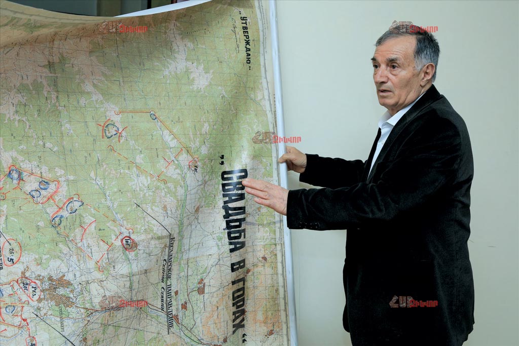
Arkady Ter-Tadevosyan pushes the iron door. We are in the building under reconstruction, where he intends to establish a museum of the liberation of Shushi. This is where the “godfather” of the operation keeps all the documents confirming the victorious episode: armament calculations, operative plan, reconnaissance drawings, handwritten notes. Most striking, however, is the 1: 50,000-scale topographic map on the wall of the room, a copy of the original handed over to the military museum. “Before the operation, we asked them to send a map from Armenia. But it was difficult, it did not work. There was a Soviet military unit in Stepanakert where a large number of maps were kept. The boys brought two trucks loaded from there. And we chose this one,” says Commandos, taking the stick in his hand and approaching the map. He shows the notation “top secret” in black in the right corner. “Here we were making the final decisions, and we were working out the plan of attack on the working maps. One was always on my desk. Anyone who came in and out could advise, suggest some option. I will never forget the next morning of the liberation of Khojalu, when the young fighter, whom we all called “Chicken”, put his finger on Shushi and asked: “Commander, when are we going to attack?” the Major General says with a smile on his face. The other maps were always folded, opened in secret. Probably that is the reason why they are “wrinkled” today. “We developed the attack plan in March-April. We regularly asked the commanders of the main directions to specify this or that section on the map: how many paths are there, how many roads, how many bushes? We had to carefully study the location of the enemy. We had little ammunition. Through the efforts of the intelligence groups, we knew the names, slogans, quantitative and qualitative data of all the Azeri commanders in Shushi. The commanders plotted the information obtained from the search on a working map.” After making adjustments in the planning of the military operation, we moved the notes to the main map,” Commandos recalls, pointing to the blue circles, which are the enemy’s strongholds and firing points. Shushi was defended by an Azerbaijani military contingent of 2,800 people. And when on April 10 Arkady Ter-Tadevosyan showed the map to Vazgen Sargsyan, the latter expressed an opinion that at least ten thousand people would be needed for the attack. “It simply came to our notice then. According to military theory, the attacking side should be able to provide a threefold advantage of forces, but in the mountains – a fourfold advantage. Naturally, we did not have that much power. During the consultation, I told the boys that it would be very difficult. I offered to wait a little longer, to prepare better. But both the 72 commanders and the leaders of the main directions insisted that the fortress city should be liberated, otherwise nothing would be left of Stepanakert. The enemy was transporting ammunition from Aghdam warehouses to Shushi day and night. From there they were constantly bombing Stepanakert. By May 8, 1992, about three-quarters of the city had been destroyed. “So the commanders had to obey my order, but strange as it may seem, I obeyed their order.”
 If in some circles of Armenia they were against the “crazy attack”, the “seemingly impossible liberation”, in Artsakh, on the contrary, they were determined. The attack was supposed to start on the night of May 4-5, but the heavy snow changed the plans. The “Wedding in the Mountains” operation was postponed for three days. “On May 5, the detachment led by Nver Chakhoyan once again searched the direction of Zarslu and the road to Lisagor. He reported that the enemy had set up mobile bases along the road. I did not believe it. We searched the place the day before. It was clean. I said, “Nver, can you prove it?” He found a large camera resembling a suitcase. He took pictures and brought facts. “Based on the information received, new adjustments were made to the military operation map.” When the map was ready, first Commandos and the head of the headquarters of the self-defense forces Felix Gzoghyan ratified it, and finally the then chairman of the Artsakh Defense Committee Serzh Sargsyan confirmed it. “In the upper left corner is President Sargsyan’s signature. It was not an easy decision. I was verbally told that NKR Supreme Council also approved the action. I asked for a document, but I did not receive it. This map became my main command,” says the commander.
The 35-kilometer stretch of firing points on the outskirts of Shushi made it impossible to launch offensive battles across the front. It was decided to attack the city from four directions. The name of each commander is underlined on the map. “On the night of May 8, at 2:30, an attack order was issued. The attack on the fortress city started in four directions. The direction of Stepanakert (northern) was headed by Valeri Chitchyan, the direction of Shosh village (eastern) by Arkady Karapetyan, the direction of Lachin (southern) by Samvel Babayan, the deputy commander of the self-defense forces, and the direction of Kosalar-Janhasan (northwestern) by Seyran Ohanyan. The commander of the reserve was Yura Hovhannisyan. The enemy considered the Kosalar-Janhasa attack possible and always kept that point under fire. They considered attack on Shushi nonsense.” After a long slide, the pole stops at a hill north of Shosh. From this point taken in the red circle, Commandos led the military operation. “Everything went smoothly until our tank was hit here. I saw that episode very clearly from the command post. It was the hardest moment. Panic broke out. For a moment it seemed that the operation was in jeopardy. I immediately asked Felix Gzoghyan to go north. The forces were recounted… The attack continued. We had to attack on the first day, take Shushi in the ring on the second day, and liberate the right and left sides on the third day. But our boys did the job in 26.5 hours. ”
It was May 9, at 4:30 in the morning. Ter-Tadevosyan was informed that the city was liberated. He carefully folded the map and put it in a field bag. “I did not know what to do, to tell people or not? There were still mines in the city, people could be killed. “I fought with myself until 8 in the morning,” Commandos recalled. When he announced that there was no more enemy in the city, he fell asleep at the command post. Because he had not slept for several days. “I really wanted to have fun with my soldiers, but unfortunately my body could not stand it. Only in the evening did I realize what it means to liberate Shushi.”
P.S. Every year, according to tradition, Arkady Ter-Tadevosyan goes to Shushi to celebrate the great victory. He walks through the mountain town, where every stone, every road is familiar to him. And he really wants Armenia to be depicted on the world map through Shushi, for the liberation of which forty-eight fighters sacrificed their lives…
By SHUSHAN STEPANYAN
Photos by AREG VARDANYAN
Category: #13 (1384) 7.04.2021 - 13.04.2021, News, Spotlight, Pages of History


